Ten years ago this month the residents of Limavady were still getting used to their long-awaited bypass, which had finally opened to traffic on 4 July 2003. The official opening took place on 24 September. Limavady is a sizeable town of over 12,000 people but it also lies mid way along the A2 / A37 route which links the two main settlements on the north coast: Derry/Londonderry and Coleraine. This is part of what is officially called the “Northern Key Transport Corridor”. All of the traffic on the route was having to trundle down the main street of Limavady, clogging up the town and interfering with residents who wanted to go shopping or get to schools and workplaces. In 2001, when work began on the bypass, the main street was registering traffic flows of almost 19,000 vehicles per day – comparable to what the A1 dual-carriageway on either side of Newry is carrying today.
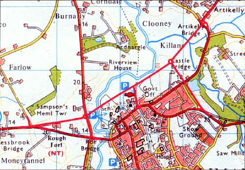
It had been obvious for many years that something had to be done to get long distance traffic out of Limavady’s town centre. In fact, the first proposal was made in 1964, when it was announced that a new motorway (the M23) would be built between Ballymena and Derry, bypassing Limavady to the north. Needless to say, this never happened. The plan was reduced in ambition to an all-purpose (ie A-class) trunk road bypass in the 1970s, but it never got off the drawing board throughout the 1970s, 80s or 90s. In 1991 a 3.6 km route was chosen that would pass north of the town centre, and it was this route that was eventually built. (You can see a more detailed map of the route here). The bypass is not so much a traditional “bypass” as a T-shaped set of three roads with a new roundabout which join the three main routes in and out of the town: the A2 from the west, the (less heavily trafficked) A2 from the north-east and the A37 from the south-east.
A Direction Order (required to allow the government to build a new trunk road) was granted in 1994, and the Vesting Order (required to allow the government to buy the required land) came into effect in 2001. Work began in December 2001. The consulting engineer was Ove Arup & Partners, the architects were Scott Wilson and Ferguson McIlveen and the contractor was Grahams. The scheme cost £11.5m at 2003 prices.
Challenges
The scheme presented many engineering challenges, principally the fact that it was built across a wide, ecologically-sensitive flood plain which was not only prone to flooding, but consisted of a thick layer (over 5 metres) of waterlogged glacial, estuarine and fluvial sediments. The main river to be crossed was the River Roe, requiring a bridge of 40 metres, but to the east there also had to be a 25 metre bridge over the smaller River Curly. A third bridge was required to carry the Dowland Road (hitherto the main A2 out of the north east of the town) over the bypass, which was to be in a cutting at that point.
Much of the information in this blog, and all the images, are from the archived Roads Service page on the scheme, accessible here for those who are interested (see copyright information). We are blessed that somebody in Northern Division of Roads Service seems to have a real interest in history and scheme information, so unlike the other Divisions, schemes that take place in the Northern section generally come with lots of fascinating information like this. Thank you, whoever you are!
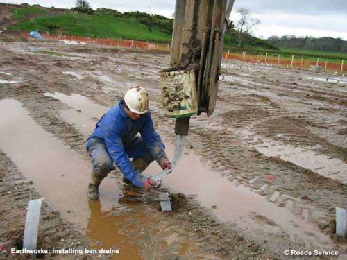
Where it crossed the floodplain, most of the road had to be raised on 3 metre embankments to prevent it being submerged during floods. The extra weight that the construction of an embankment adds to soft ground usually causes it to move around over a period of months as it “settles” to a new equilibrium and water is squeezed out by the extra pressure. It is not possible to build a road until the settlement has stopped, so to speed things up engineers install hundreds of vertical “drains”, that allow the water to move upwards much more quickly. This is shown in this photograph:
The embankments were further stabilised by being built up in layers, with sheets of fabric between them. This photograph shows part of the embankment taking shape. If you click to zoom in, you can see dozens of the band drains sticking out of the earth.
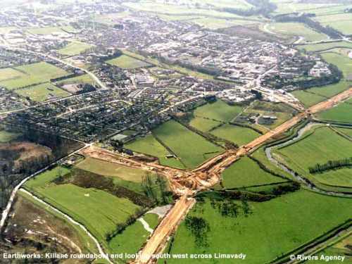
The photograph below shows how the bypass looked part way through the works when the embankments were being constructed. The point where the three arms meet is the site of a future roundabout.
Bridges
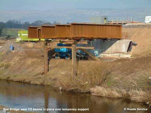
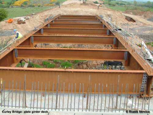
The largest bridge on the Bypass is the River Roe bridge. This, and the River Curly bridge, were the first “integral bridges” to be constructed in Ireland (an integral bridge is basically one without joints). Due to the ecological sensitivity of the area, no structures were permitted in the water itself, so large cranes had to be employed to lift the central spans as a unit. Not only this, but since the ground consisted of soft alluvial clay, very solid piled foundations were required for the bridge piers that would support the single 40 metre span. The four pictures below show the works as they progressed:
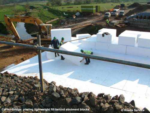
The Curly River bridge is smaller, with a 25 metre span, but of a similar design to the River Roe bridge. At this location the ground was so soft that the bridge abutments were back-filled with polystyrene blocks rather than earth, to reduce the weight. This must have been interesting work in windy weather! The bridge also carries a pipe, which looks to be either a water main or a sewer.
The stretch of bypass that connects the central roundabout to the A37 to the south-east of the town had to pass through an area of raised ground (actually a post-Glacial raised beach) which required a cutting. A short stretch on the north-east arm out of the town at Killane similarly required a cutting. The loose nature of this material made it relatively easy to excavate.
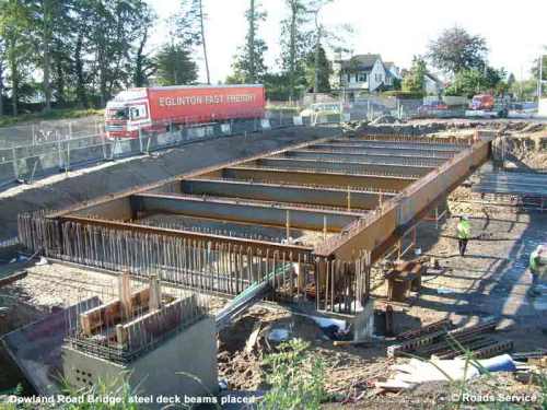
The existing A2 out of the north-east of the town, Dowland Road, was to be bridged over the bypass at this point without access. This 32 metre span bridge was built using top-down construction techniques, with the main road diverted to one side. Once completed, the road was reinstated over the bridge and the rest of the cutting excavated.
 Other Points
Significant archaeology was uncovered during the works, as was expected due to the long history of human habitation at this location. There is more information on what was discovered here.
The south-eastern arm of the Bypass passed through the edge of the Drenagh Estate, and very close to an historic area of trees known locally as the Doctor’s Belt trees. Unfortunately even after the best design work, some trees here did have to be cut down, and hence the scheme included a commitment to plant a large number of new trees, as well as purchasing the remainder of the Doctor’s Belt and taking responsibility for its future management.
Completion of the Bypass
The Bypass was completed and opened to traffic on 4 July 2003. A number of short link roads were built to connect various parts of the town to the bypass, allowing traffic to enter the town at the most appropriate point, rather than driving through the middle.
The impact on long distance traffic was significant. By removing them from the town centre, the scheme gave reduced journey times, most noticeably at peak times. In 2009, the bypass was carrying 12,300 vehicles per day.
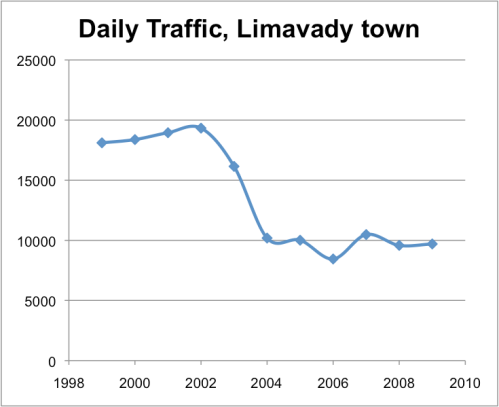
The impact on the town was also very significant. The graph below shows [annual average daily] traffic levels passing through the town before, during and after the bypass works (DRD traffic data, measured at Ballykelly Road near Roe bridge). As you can see, traffic levels roughly halved, and remained at this reduced level, greatly improving the environment in the town, thus demonstrating how a well-designed bypass can bring huge benefits to a local area.
The Limavady Bypass is now ten years old, and its vegetation has matured well in that time. The road has become a reliable fixture in the Limavady area. A superb piece of engineering.





Leave a comment